.avif)
Freevisuals
Drone & Aerial Dehaze is a free 3D LUT with boosted contrast and clarity, built to cut through atmospheric haze common in drone and aerial landscape...
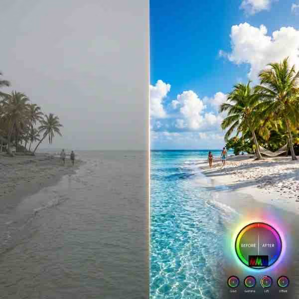
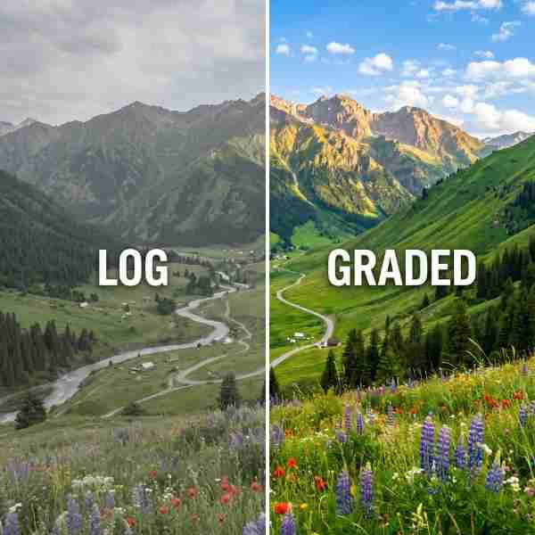
Download FREEGo Pro To DownloadDownload NOW!Drone footage faces a specific optical challenge most ground-level filming never encounters, atmospheric haze. The greater the altitude and distance between camera and subject, the more atmospheric particles, moisture, and pollution sit between the lens and the landscape, producing a flat, washed out, low-contrast result even under otherwise clear conditions. Drone & Aerial Dehaze is built to counter this directly, boosting contrast and clarity specifically to cut through this atmospheric interference and restore the crisp, defined look aerial footage should have.
This is a genuinely technical, corrective LUT built around a specific optical phenomenon rather than a purely stylistic choice. For music to pair with drone and aerial landscape content, Artlist and Epidemic Sound both carry sweeping, cinematic tracks well suited to aerial landscape content.
Format: .cube (33-point 3D LUT), compatible with DaVinci Resolve, Adobe Premiere Pro, Final Cut Pro, and any other software that supports standard .cube LUT files for drone and aerial video workflows.
Atmospheric haze results from light scattering off tiny particles suspended in the air, water vapor, dust, pollution, and other aerosols, and this scattering effect increases substantially with the distance light has to travel through the atmosphere before reaching a camera's sensor. Ground-level photography typically involves much shorter distances between camera and subject than aerial photography, meaning haze has a proportionally smaller effect on typical eye-level shots. Drone footage, by contrast, frequently involves both significant altitude and substantial horizontal distance to distant landscape features, exactly the conditions under which atmospheric haze has its most pronounced flattening, desaturating effect.
This is a genuine optical phenomenon rather than a camera or drone specific flaw, the same haze that affects drone footage would similarly affect an equivalent shot taken from a tall building or mountain viewpoint at similar distance and altitude. Drone & Aerial Dehaze addresses this by applying targeted contrast and saturation correction calibrated specifically to counteract haze's known optical characteristics, restoring definition and color that the atmosphere itself has genuinely reduced before the light ever reached your camera's sensor.
The core use case this LUT is built for, restoring crisp definition and vibrant color to expansive landscape drone footage that would otherwise appear flat and washed out due to atmospheric haze.
Real estate drone footage showing property boundaries, surrounding landscape, and neighborhood context benefits from clearer, more defined presentation this LUT provides.
Aerial documentation of construction projects and land development benefits from clear, well-defined footage that accurately represents site conditions and progress.
Agricultural drone content, crop monitoring, and farm surveying benefits from enhanced clarity that helps distinguish subtle variations across large land areas.
Aerial establishing shots for tourism and destination marketing benefit significantly from this LUT's ability to present landscapes at their most crisp and visually compelling.
Download the .cube file from the link above.
Go to File > Preferences > System > General, then click Open LUT Folder. Copy the downloaded .cube file into this folder.
Resolve needs to be restarted, or the LUT list refreshed manually, before the new LUT appears in your browser.
Right-click your clip's node, choose LUT, and select Drone Aerial Dehaze from your custom LUT folder.
Add Lumetri Color to your clip, open the Lumetri panel, go to Creative, click Browse under Look, and select the .cube file directly.
Place the .cube file in your custom LUT folder and apply through the Color inspector.
Log footage preserves considerably more usable contrast and color information for this LUT to work with compared to a standard, already-processed picture profile.
Clear, low-humidity days with good visibility naturally reduce the amount of haze correction needed, giving this LUT less work to do and generally producing better final results.
Aggressive contrast boosts can occasionally introduce or exaggerate compression artifacts, particularly in highly compressed drone footage, review carefully at full resolution.
If you can recall or reference how the actual landscape looked in person, compare your graded footage against that memory to confirm the correction feels accurate rather than overdone.
Applying maximum correction intensity regardless of actual haze severity. Footage with minimal haze may look over-processed if this LUT's full correction intensity is applied unnecessarily, adjust based on your specific conditions.
Shooting in already highly compressed or processed camera profiles. Standard picture profiles discard information this LUT could otherwise use for more effective correction, log or flat profiles preserve considerably more usable data.
Ignoring air quality and visibility conditions when planning flights. Days with poor air quality or high humidity produce more severe haze that even strong correction can't fully overcome, planning around better conditions produces meaningfully better results.
Not checking for artifacts after aggressive contrast enhancement. Compressed drone footage can show visible artifacts once contrast is significantly boosted, review carefully rather than assuming the correction is artifact-free.
DaVinci Resolve Tutorial: Zoom In And Out (Ken Burns Effect), useful background if you're combining aerial video with still drone photography within the same project.
It's worth understanding that any dehaze correction, including this LUT, works by enhancing contrast and color within the range of information actually present in your source footage, it cannot manufacture detail or color information that atmospheric conditions have genuinely eliminated entirely. In cases of severe haze, heavy smog, thick fog, or very poor air quality, so much of the original scene's contrast and color information may already be lost before it reaches your camera's sensor that even aggressive correction can only partially restore a usable result, and the final footage may still show visible limitations regardless of grading effort applied afterward.
This is an important distinction from many other correction scenarios, where source footage typically retains enough underlying information for skilled color grading to fully restore a polished result. Severe atmospheric haze represents a more fundamental data loss problem, similar to trying to sharpen a photo that was originally captured out of focus, no amount of processing can fully recreate detail that was never actually captured in the first place. Setting realistic expectations for what correction can achieve under genuinely severe haze conditions, and prioritizing flight timing and location choices that minimize haze exposure in the first place, produces considerably better outcomes than relying entirely on post-production correction to salvage difficult atmospheric conditions.
While atmospheric haze represents the primary optical challenge this LUT addresses, drone footage often presents several other related technical considerations worth understanding as part of a complete aerial cinematography workflow. Drone camera sensors are typically smaller than those found in dedicated cinema or even many consumer cameras, given the weight and size constraints of airborne equipment, which can result in comparatively more visible noise in shadow areas once contrast is boosted during grading. Applying appropriate noise reduction before this LUT's contrast enhancement helps manage this consideration, similar to the approach recommended for other noise-sensitive content types throughout our LUT library.
Compression is another factor worth considering specifically for drone footage, since many consumer and prosumer drones record using more aggressive compression than dedicated cinema cameras, in order to manage file sizes and storage limitations on airborne equipment. This more aggressive compression can become more visible once significant contrast enhancement is applied, appearing as blocky artifacts or banding in areas of subtle tonal gradation, like smooth sky or water surfaces. Shooting at your drone's highest available bitrate setting, where storage and battery considerations allow, helps minimize this issue and gives this LUT's contrast enhancement cleaner source material to work with.
For creators or businesses regularly producing aerial content across multiple projects, establishing a consistent workflow around this LUT, appropriate camera settings, and flight planning around favorable atmospheric conditions creates a genuinely valuable, reusable content library over time. Aerial footage, unlike many other content types, often has broader reusability across different projects, a strong aerial establishing shot of a landscape or property can serve multiple different marketing or content purposes beyond its original intended use, making the investment in optimizing this specific footage type particularly worthwhile for organizations producing aerial content regularly.
Organizing this footage library by location, date, and atmospheric conditions at time of capture, similar to the approach recommended for other seasonal or condition-dependent content types, helps identify your strongest existing aerial assets quickly when planning future projects, rather than needing to schedule new flights every time aerial footage of a familiar location is needed for a new specific purpose.
Beyond the technical and creative considerations this LUT addresses, it's worth noting that drone operation itself is subject to specific regulations in most jurisdictions, covering areas like maximum altitude, restricted airspace near airports, and registration requirements for the drone operator. These regulations exist for legitimate safety reasons and vary considerably between different countries and even different regions within the same country, making it worth confirming current local requirements before any drone flight, particularly for commercial content production where regulatory compliance carries additional business implications beyond simply personal legal risk.
Many jurisdictions also have specific privacy regulations relevant to drone photography, particularly around filming private property or identifiable individuals without appropriate consent, which content creators should understand and respect regardless of how compelling the resulting footage, once appropriately graded with this LUT, might look. Building drone content production around a solid understanding of applicable regulations from the start avoids potential legal complications that could otherwise undermine an otherwise well executed piece of content.
For commercial drone operators specifically, many jurisdictions require a specific commercial drone pilot certification separate from recreational drone use, and confirming your specific certification status and insurance coverage before accepting commercial aerial content work protects both the operator and any clients relying on that content for business purposes, a consideration worth building into any commercial drone content workflow from the very beginning rather than addressing reactively after a specific project has already been booked.
None of these regulatory considerations directly affect how this LUT performs technically, but they represent an essential part of the broader professional practice surrounding drone content production that any serious aerial content creator or business needs to navigate alongside the purely creative and technical aspects of capturing and grading compelling footage.
It significantly reduces moderate haze effects, but cannot fully restore detail lost to genuinely severe atmospheric conditions like heavy smog or thick fog, since that detail was never actually captured by the sensor in the first place.
If your drone supports it, yes, log footage preserves considerably more usable contrast and color information for this LUT to work with compared to a standard rec709 picture profile.
It can if applied to highly compressed source footage, shooting at your drone's highest available bitrate helps minimize this risk considerably compared to lower bitrate recording settings.
Yes, though its correction is most impactful for longer-distance, higher-altitude shots where haze plays the largest role, close-range footage will show a more subtle effect from this LUT's treatment since haze has less distance to accumulate over.
Yes, free for both personal and commercial drone and aerial content production, including real estate, tourism, and agricultural marketing applications.
Yes, though it's specifically calibrated for the haze-related challenges common in longer-distance, higher-altitude aerial shots rather than close-range drone footage where haze plays a much smaller role.
Yes, clearer, lower-humidity conditions naturally produce less haze for this LUT to correct, planning flights around favorable atmospheric conditions improves overall results considerably compared to flying in poor visibility.
Affiliate Disclosure: This post may contain affiliate links. If you make a purchase through one of these links, FreeVisuals may earn a commission at no extra cost to you. We only recommend products and platforms we genuinely believe in. Read our full disclosure policy.
%20Profile%20Pic.jpg)
Download free video templates, LUTs, and presets for Premiere Pro, After Effects, DaVinci Resolve, CapCut, and Final Cut Pro.
.jpg)